Missoula to Lee Creek Campground near Lolo Pass, MT & ID

DSC_0863
We got an early start out of Missoula and headed up into the mountains for some cooler air. Trying to find a place where the air is naturally cool so I don’t have to run the A/C all the time. Basically that’s not happening. Global Climate change has been setting high-temperature records in Oregon again this week (someone hit 107*F) and it’s cooler in New Mexico than it is on the plains of Oregon and Washington.

DSC_0861

I’ve found myself once again on the trail of Lewis and Clark. I followed the Corps of Discovery (discovered a corpse?) on a trip from west to east way back in the early 1990’s (when you could still see their footprints in the mud). Now I’m on the route they took over the mountains in the fall of 1805 and back again in the summer of 1806. I was reading about how they nearly lost some toes to frostbite in September and I’m wishing it still got that cold. If they did that trip now it would be heat-stroke they had to worry about!

DSC_0860

Lolo Pass visitor enter – Wifi here. Free plus a donation 🙂

I took the tour at the Smokejumpers Visitor Center in Missoula. Very interesting. When I was in Alaska I spent some time picking smokejumpers up and taking them back to a firebase. Not much has changed in their profession since then except there are more Ram-Air parachutes now than there were then. Still get to jump out of a perfectly good airplane into a burning forest (or tundra if they are in way-north Alaska). The day after my Smokejumper tour a fire broke out on a ridge not far from camp. A couple helicopters drained a nearby pond and dumped it on the fire.

DSC_0862

Packer Meadows

IMG_2012

Above the camp site

There are some hiking trails and logging roads near our campsite so we hiked the hikes and biked the roads to see the sights

IMG_2013

Near by creek

Sandpoint, ID to Missoula, MT

IMG_2011
Google says 3.5 hours between Sandpoint and Missoula on I-90. Mother Earth says 6 hours. There is a lot of work being done on I-90 so slowing down and dealing with two-way traffic is a regular thing. Also I have a new entry in my worst roads list. I-90 east-bound from the state-line to Superior, MT is a rough-ass ribbon of concrete slabs stitched together by pot-holes. It’s good that they are fixing it, but they are fixing it by pouring new concrete slabs which will be rough just like the old stuff in a few weeks. Stupid concrete! Asphalt is the smooth ride!

If I had that trip to do over I’d take MT 200 up the Clark Fork River to where it meets I-90

Nelson, BC to Sandpoint, ID

DSC_0858
We left Nelson about mid-day and headed south on hwy 6 toward the USA border crossing at Nelway. It was a lovely drive through the mountains to the border and the check-in to the US was quick. From the border south on Washington 31 was winding and hilly until we hooked up with the Pend Oreille river. From then on it was a slight grade with rolling hills through hay fields and past high-end waterfront properties. Quite a few small towns dot the landscape and we slowed to 45 then 25 for each one. After two weeks of thinking about speeds and distances in Km it’s strange to now see signs in Mph. Diesel fuel is $3.40-ish in Idaho which is about $2 cheaper than BC so we got that going for us again.

On the down-side we got trains. Lots of trains – 4 per hour, night and day, whistling the nearby crossing. I hate trains. I had planned to check out the local riding scene but trains drove me away.

Nelson: Week Two

IMG_1950

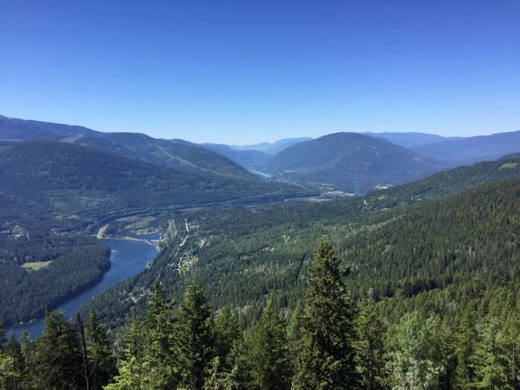
I rode the Morning Mountain area again and managed to pedal the entire climbing route up Bottoms Up and Upper Bottom to the Giveout Creek FSR. I came down via the top part of Placenta Descenta then switched over to Turnstiles because it was so much fun to ride down it last time. Apparently there was a Stage race the day before and the ever-so-polite Canadians had posted this sign:

Screen Shot 2018-07-15 at 16.33.41

If you want to be Canadian you must say please, thanks, and sorry.

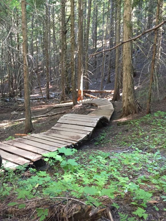
One of the features I like about Turnstiles is the high-bank turns. I don’t ride them, but they are fun to see –

IMG_1952

That’s not a fence, it’s a wooden burm and it just ends there on the right. After that riders just fly it out and enter the next drop.

IMG_1959

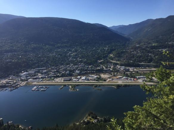
View from Pulpit Rock

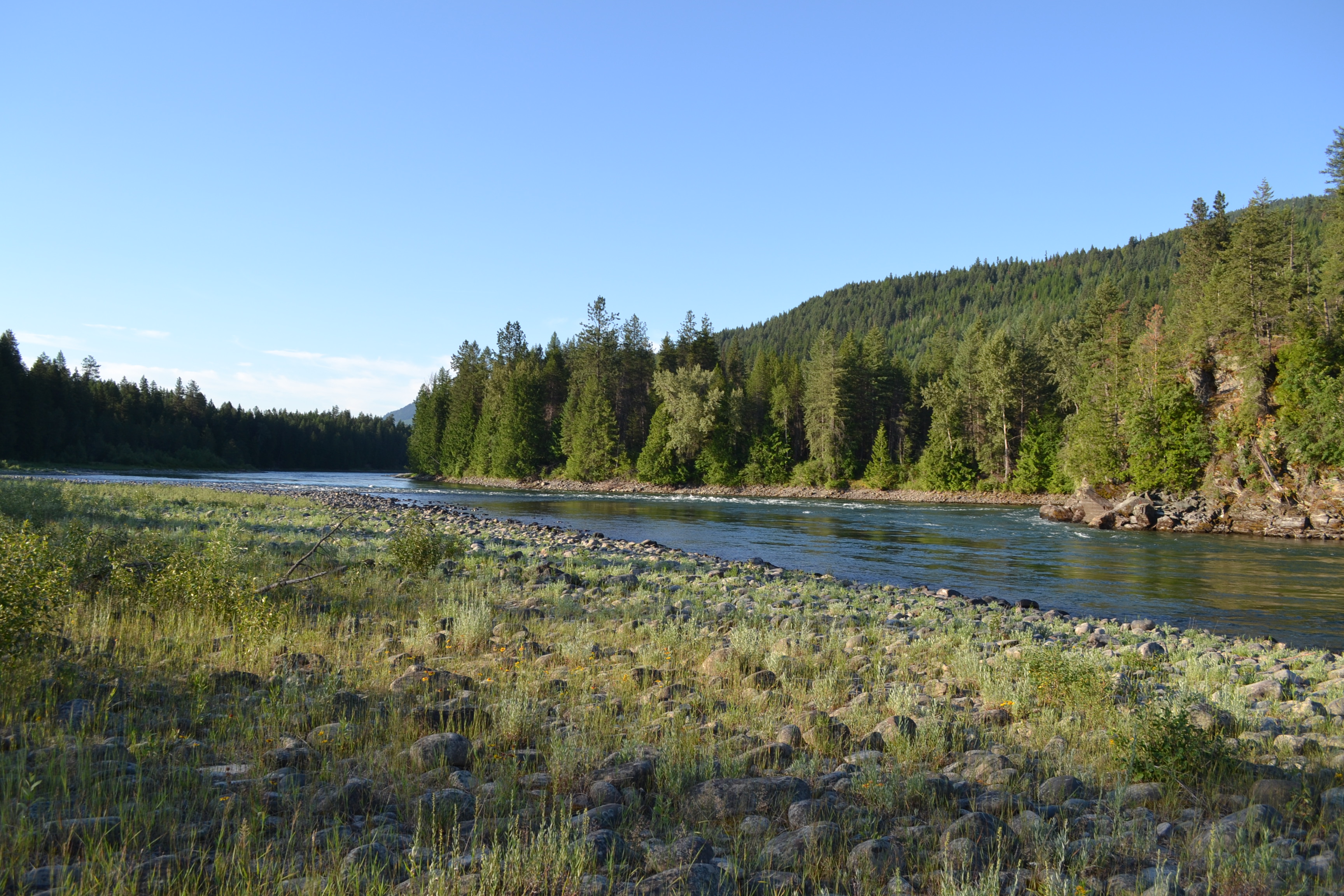
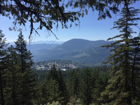
Next day I went for a hike up to Pulpit Rock then on to the Flagpole. I figured I’d get an early start and beat the heat and the crowds. Since it was a Monday I thought I’d have the place to myself but apparently not. Pulpit Rock is a popular climb with the Get-In-A-Hike-Before-Work-Crowd and the main lot was full when I arrived. I parked in the overflow lot and began the 40-minute climb up what is essentially a staircase that ascends through a dense forest. The view from Pulpit Rock is worth the climb. Hikers are rewarded with an Above-The-Airplanes perspective of Nelson. Really, we watched planes fly past and they were lower than us.

IMG_1961

View from the Flag Pole above Pulpit Rock

At Pulpit Rock I met up with a fellow-camper Charlie and his dog Ziggy from the campground we’re staying in and we opted for the climb to Flagpole Lookout. It took us another 40 minutes to climb that section. The view from even higher is even better. The trip down is when I wished I had hiking poles. The steep descent was a challenge to my calves. On the way down we met the late crew coming up the trail with their kids in tow.

IMG_1968

Looking down Hall Street in Nelson, BC

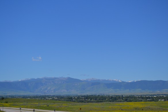
Day after that was a bike day and a get some work done on the truck day. I dropped truck 2.0 at the shop near the Kootenay River and hopped on the bike for a climb through town. As I mentioned before Nelson is steep. Like Moab the traction is great (Nelson has paved streets) and like Moab, Nelson has a lot of steep climbs. Cedar Street is pitched up at 13* and I was down in granny-gear spinning away to climb it. In the end I climbed 206 meters in 1.65 Km (675 feet in a mile). A twenty-something passed me near the top on her road bike and a local guy powered by on a downhill bike just as I reached the summit. It helps to be a mountain goat if you live in Nelson.

IMG_1966

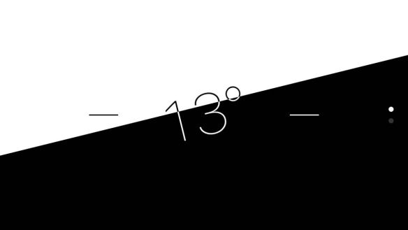
Slope-check on Cedar Street in Nelson, BC
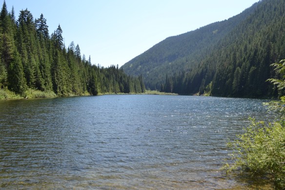
DSC_0855

Cottonwood Lake

Easy-hike day
After a serious hike the other day and a hill-climb yesterday I thought an easy hike was in order so I strolled around Cottonwood Lake and Cottonwood Falls. The lake and the falls are about 8 km apart and both are worth a look-see. The lake is south of Nelson on hwy 6 and is a watery oasis in the trees. There is a fishing dock and a few picnic tables around the edge of the lake. The railroad turned foot path runs down beside the lake and extends from Nelson to about Spokane, WA (if you are dedicated and stead-fast).

The falls are in Nelson not far from the visitor center (about a block from the weekend farmers market). The falls were inviting with their cool water-spritzed air on a day that reached into the high 80’s F. Cottonwood Falls Park is a flowery sister-park to another park in Japan and gifts from the oriental park adorn the Nelson one.
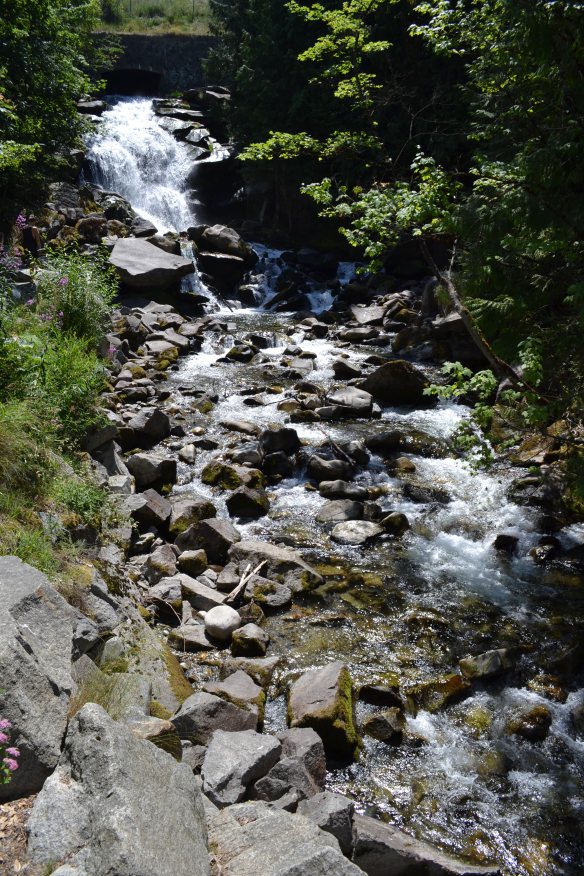
DSC_0856

Cottonwood Falls


IMG_1980

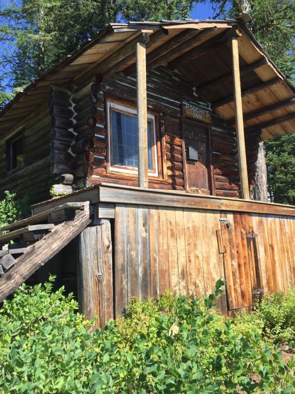
Cabin at the top of Red Mountain

Riding Rossland (pronounced Roslyn if you are Canadian or British)
Took a scenic drive over to Rossland, BC and parked at the Centennial Trail paring lot on top of the town. From the easy Centennial Trail I turned off on Moe’s and began the climb to the top of Red Mountain via Larry’s, Miner’s, and Redtop (upper). After a scenic bonanza at the summit I made the second-best choice of descending via Dreadhead. Dreadhead is an old downhill course and has many vertical drops, rocks, and roots without any ride-a-rounds. A much better route would have been to go back the way I’d climbed or perhaps to descend via Redhead. At any rate it made for a grand day out and I got in my 1.5 hour climb for the day.

IMG_1997

Summit-ed!

IMG_1979

Rossland, BC from Red Mountain

Repairs and Mods:

If you are following the saga of the EGT probe you may recall that I procured all the parts I needed yet was unable to remove one of the nuts from the turbo. I found a shop, Hywood Equipment Repair, in Nelson willing to take on the 1/2 hour task. They expertly removed the recalcitrant nut/stud and had the truck back to me before the manifold was cold. It took me about 3 hours to remove the turbo, drill the manifold, and put it all back together again. About $150 in parts, $65 cdn to remove the stubborn nut, and 3.5 hours of my time to complete the install. I wish the shop that replaced the turbo had told me I needed this before it was too late for them to do the work, but now it’s done and I can see if I’m cooking the engine. Hope NOT!!

IMG_1971

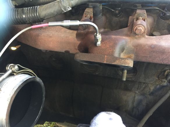
Turbo off and probe in
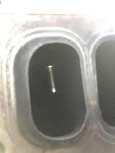
IMG_1972

EGT Probe depth

IMG_1974

All back together again


Tech report: There was WiFi at the campground which was a little slow but worked for most things. The cell service switched from Verizon to Rogers and Rogers’ data service is too slow to be of any use as a hot spot. It works for calls, texts, and getting maps, but if you want to update your blog – forget it!

Yaak River to Nelson, BC

DSC_0848

Nelson, BC

Heading north the hills got steeper and the trees got taller the closer we got to Nelson. The Mountain passes north of the border get very steep! We saw some 8% grades and there are a few stories about overheated vehicles catching fire on the side of the road. The day we got to Nelson it was about 97*F – HOT and sunny! The following day it was about 65*F and raining. Quite a switcheroo. I met up with a friend from the states and we went for a hike; got pretty soaked but the dog had fun so it was worth it.

First day riding in Nelson we went to the Morning Mountain area and rode Bottoms Up to Upper Bottom then descended on Turnstile. The two Bottoms trails are very nice climbing routes in an area dominated by downhill trails. Turnstile is a machine-made downhill course with high-bank turns and jumps. All of the jumps had ride-a-rounds so I took those. It took and hour and a half to ride up and about 15 minutes to get back down.

IMG_1944

Upper Bottom Trail

Second day riding was at the Smallwood Creek area. We rode up the Bigwood trail and when I say rode I mean hike-a-bike. The trail is a fabulous descent and a brutal climb. It’s suppose to be ridden as a downhill portion of a bigger loop. We climbed up to the scenic overlook in about an hour and the view is so worth it. The downhill portion was a hoot and took about 15 minutes to get back to the car.

IMG_1945

Looking West toward Castlegar

Nelson is a downhill riding area. The climbs are on roads or climbing trails that get you access to an assortment of downhill options. Also Canadian blue square = American black diamond trails. Canadians are tough!

Off the bike today I took the ferry ride (free) from Balfour to Kootenay Bay and back. About an hour on the water taking in the sights. We got a good view of the Kootenay Glacier area and we got to peek in the yards of some mighty expensive water-front property. My neighbors took an afternoon sailing and had lunch near Kootenay Bay. I took a morning trip before the eateries were open so I skipped the tour of town.

DSC_0849

MV Osprey

On the way back to Nelson I swung by the Kootenay Creek Provincial Park and took a hike around the visitor center. I also started up the road to the Kootenay Glacier and Old Growth trails but the road got steep and rough and I gave up, turned around, and got down. Maybe in a rental car with the damage wavier or a logging truck, eh.

DSC_0850

Suspension Bridge to Zukerburg Island

Took a side trip over to Castlegar to see what happens down river on a Saturday. Seems they generate a bit of hydro-electric power and do some fishing on the river down there. There is a park in town, Zuckerburg Island Park, that can be accessed via a suspended foot bridge. Very wobbly. Big fun! The island was home for the Zuckerburg family in the early 1900’s and now it’s a public park. Worth a stop if you are already in town.

DSC_0851

The old Zuckerburg Homestead

I’ll be in Nelson for another week so stay tuned!

Tech report: There was WiFi at the campground which was a little slow but worked for most things. The cell service switched from Verizon to Rogers (and Telus, and Bell) and Rogers’ data service is too slow to be of any use as a hot spot. It works for calls, texts, and getting maps, but if you want to update your blog – forget it!

Flathead Lake to Yaak River Campground, MT

IMG_1941

North up the length of Flathead Lake to Kalispell then northwest through Libby and into the tall trees forest. Passing north of the lake there were several fields of bright yellow flowers – WOW! I like yellow so these fields are my favorite!

We stopped for lunch in Libby and ate at the Rosauers Market. The staff in the deli was every so happy to see me! I don’t think it was just me, I think they are happy to see everyone!

There is a huge metal hawk (or eagle maybe?) in the city center (Libby) and quite a few smaller bird-of-prey statues around town.

The forest in this part of the world is much healthier than the forest in Colorado. I estimate about 1/2 the trees standing in Colorado have been killed by the pine beetle while there are very few standing dead trees in NW Montanna. There is a lot more logging going on in MT too. About one train per hour rolling down the tracks loaded with timber products. MT’s trees are also bigger than CO’s trees and the forest under-story has many small plants growing in the shade of their bigger cousins. I haven’t been here in the wet season but I suspect it’s a lot wetter than CO is.

The Yaak River splits the campground in two so we camped on the north side of the river. Tall trees blocked the sun from reaching down to the solar panel and exciting the electrons therein so we had to go easy on the electricity that night. Even though the campground is between the highway and the RR tracks it’s mostly quiet. Highway traffic is minimal at night and there are no whistles from the trains.

Tech report: No cell service between Troy MT and Bonners Ferry ID.

Delmoe Lake Rd to Flathead Lake, MT

DSC_0822
We got an early start and refueled in Butte. We saw several places where people had staked their claim on the edge of the parade route getting ready for the big 4th of July festivities.

DSC_0827

Back on the road we headed west then north to the 1000 Buddhas Garden just north of Arlee, MT on hwy 93. In Arlee they were having a pancake breakfast at the firehouse; the line was around the block. We arrived at the 1000 Buddhas Garden about 11 and had the place to ourselves for about half-an-hour. I enjoyed a leisurely walk around the statues (no I didn’t count them) and a hike up the hill to where the prayer flags fluttered in a gentle west wind.

DSC_0830

DSC_0828

DSC_0826

After cooling our jets at the peaceful 1000 Buddhas we headed north to Flathead Lake. I reserved the last available camp spot at Finley Point State Park a month ago and today found out that it’s right on the edge of the lake where many holiday boaters, beach-goers, and campers eagerly awaited the fireworks display over the lake.

DSC_0832

Sunrise the next day caught a fair number of people sleeping on the edge of the lake while the crows were picking through the festivity left-overs.

IMG_1939

The lake is a delight from 5am to about 10. At 10 the power-boaters start their day and after noon the beach-goers arrive to splash in the near-freezing water and squeal about how cold it is.

I went for a ride on the local roads around Finley Point. There are a lot of cherry orchards on the point as well as vacation homes. There are a few places that look like full-time residents, but I suspect the population drops off in the winter around here.

Tech report: There were 3 bars of 3G service and 1 bar of LTE service at the campground. Call and text ok, super slow internet connection.

Springtime to Delmoe Lake Rd

DSC_0817

Crazy Mountains in the distance

Further west today we climbed away from the Yellowstone river and northward toward Butte, MT. We found a camp-spot off of the road to Delmoe Lake and spent the afternoon under gray skies and an intermittent rain/ hail mix.

DSC_0820

The morning low was 33* and a heavy dew coated all the cold surfaces at sunrise.


*

Sheridan to Springtime, MT

DSC_0816

The Native American Monument

We stopped by the Little Bighorn Battlefield Monument between Sheridan, WY and Billings, MT. I was last here in the early 1990’s and since then they have built a native american memorial site which has many quotes from the defenders who fought in that battle. The first time I was here was in winter and the crowds were very thin. I might have been the only one there that day. This time I went in early July, about a week after the June 25th date of the battle, and it’s much warmer, and there are many more people! Schools out!

DSC_0815

Little Bighorn Battlefield in bloom

The balance of the day was spend following the Yellowstone river toward the west. The river valley is green this time of year and the pastures are dotted with cows and horses.

Casper to Sheridan, WY

DSC_0810

West of town lie the Big Horn Mountains

My friend Kurt has been living in Sheridan for about 33 years now and I haven’t been here in about 16 years so it was high time I stopped by. Sheridan is a delightful town in an beautiful area of Wyoming (In early July anyway. In winter it’s 30-below and icicles dangle from the ears of cows like chandelier earrings). There is a long and rich history of indigenous Americans, the wild west, and ranching. There are several nearby museums chronicling the history of the area.

IMG_1933

A surge dam from the log flume system

Kurt and I took a drive through the Big Horn Mountains. We followed the trail of the Tie hacks (people who cut railroad ties for the transcontinental railway system) from the high country down the log flumes to the place where the sawmill use to stand. We also stopped at the Antelope Butte ski area for a fundraiser. The ski area shut down 14 years ago and will re-open this winter. The day we were there it was cool and a bit rainy, but the brats were hot and tasty. Lots of local people are excited for the reopening of the ski slopes this winter.

IMG_1935

Kurt and I at the Antelope Butte Ski Area fundraiser

In addition to my high-school friend Kurt and his wife Jody, I also got to meet up with Kurt’s mom and discovered to my delight that Kurt’s brother Toni and his wife Cathy had moved back to Sheridan and set up their own ranch.