Datil, NM

West-bound again and down from the mountains across the Rio Grande where there was not a single drop of agua in the parched and sandy river bed. I was shocked that such a symbolic waterway was high and dry.

DSC_0718

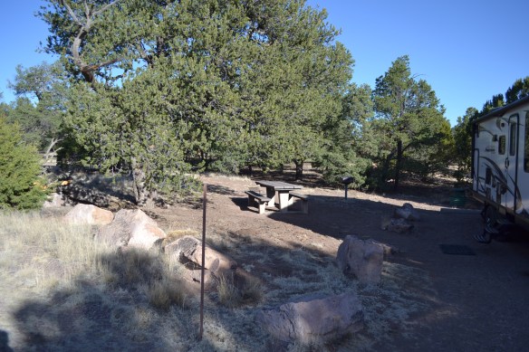
West of that once mighty-river turned dusty-trail we climbed back into the mountains eventually reaching 7500 feet and the BLM campground at Datil, NM. With highs in the 70’s and lows near freezing the temperature was delightful. The 22-spot campground is tucked into the trees, has almost 4 miles of hiking trails, and a visitors center with a WiFi hot-spot. We were here the last weekend in April and there were only 4 other campers.

DSC_0720

I took a side trip to visit the Very Large Array (VLA) Radio Telescope on the Plains of San Agustin valley. The visitors center is open from 8am to sunset. Since the array is closed on T-day, X-mas and new-years day I suspect the visitors center might be too. There is a nice walking tour of the grounds near the visitors center and descriptions of all the gizmos and do-hickeys. There is a short orientation movie (I skipped it because I wanted to be dis-oriented), an inside exhibit space, and the walking tour all for just $6 admission. I spent about 1.5 hours on the walking tour including walking to the antenna barn instead of driving.

DSC_0721


Fort Stanton, NM

IMG_1806

As we left Roswell the irrigated fields of the Pecos River Valley gave way to rolling brown hills and west-bound Hwy 380 eventually began to climb a valley into the mountains.

We made camp at the Fort Stanton Equestrian Trail head which is about the same place as the Rob Jaggers Camping Area. The camp area is near Capitan, NM – birthplace of the bear cub who would become Smokey the Bear – it’s a fine spot and at 6300 feet above sea level it’s fairly cool. There are camp spots with water and electric ($5 each connection) and there are several spots without hook-ups and they are free.

I took the walking tour of Fort Stanton and learned about the history of the place as a military fort and as a hospital. Near-by is a cave system that stretches for over 30 miles (when we were there the caves were closed for research projects). The area also has nearly 100 miles of trails open to horses, hikers, and bicycles.

IMG_1805

In Capitan I went to see the Smokey the Bear Historical Park where I was reminded about the story of the Smokey the Bear campaign and the discovery and rescue of the little bear cub who would become the living symbol of Smokey the Bear.

Small-talk at the market in Capitan was about how dry the winter and spring had been. The grass and plants in the meadow near our camp were dry and crunchy – it sounded like walking on soda crackers. Much the same conditions as those in 1950 that lead to the fire which orphaned the little bear cub.

Bottomless Lakes State Park near Roswell, NM

DSC_0717

I choose to stop here because it was along my path and it held the promise of an electric hook-up in the day’s 87º high temperature. It turns out that in addition to electricity it is New Mexico’s first State Park which was founded in 1933. The lakes are not actually bottomless, the deepest is about 90 feet, the shallowest around 18 feet deep, but there is a fascinating crescent shaped building with a tower around the swim beach. I can imagine what a grand place this was when it was new.

Bottomless Lakes SP is close enough to Roswell that I could run into town for supplies. There is a Target, Walmart, several nice grocery stores, and gas stations galore. The park also hosts a free WiFi hot spot so that’s super convenient.

In addition the the grocery-run I took a tour of the airport south of town. The Roswell airport is an airplane graveyard and there are a great many retired airliners in different stages of getting recycled. It is like recycling aluminum cans on a huge scale.

On my walk around the campground in the evening I met Kate and Francis who are nearing the end of their year-long travels in a jeep Liberty (TravelsInLiberty.com) and looking for a home south of the snow.

Post, Tx

Heading west the rolling green hills near Jacksboro slowly morphed into flatter, browner terrain including flat-top mesas bristling with wind-farms. Highway 380 in west Texas has a surprising number of roadside sculptures. We saw an enormous steel bull (to be expected) a cute little red fox, and a large steel prickly-pear cactus in full bloom (two surprises).

IMG_1798

I saw this on the horizon from about 15 miles away.  I stopped and counted the bullet marks on the big brown bull. There were about a dozen hits to the left cheek. This sculpture is on Highway 380 between Throckmorton and Haskell (I think).

I had originally planned to make camp east of Post TX and then stop overnight at Coleman Park, the City-owned camp ground in Brownfield TX. As it turned out I only stopped there to use the dump-station and add some water to the tanks. I was quite impressed with the facilities and the cost was a donation to support the camp ground.

Fort Richardson State Park in Jacksboro, TX

DSC_0710

The plains of north Texas slowly gave way to rolling hills and trees during the drive down. The sight of wind farms remained constant along our route while natural-gas wells and cotton fields faded to oil wells and pecan orchards.

Fort Richardson was a delightful place to spend a long weekend. I took a tour of the grounds and chatted with the tour guide for awhile on Friday when I arrived. I came to this part of Texas to meet old friends and we had a cook-out, caught up on the years that have passed since last we meet, and ate some fine Texas brunch.

IMG_1795

Me, Lana, (holding Gus) and Mike

We visited the big knife at Bowie, Tx

IMG_1797

And the gas, groceries, motel, and restaurant built from petrified wood.


Fair Park in Childress, TX

DSC_0705

Fair Park is a delightful place with a large pond, walking trails, and picnic tables. Nearby are the outdoor stadium, swimming pool, and softball fields. The pond is home to a variety of birds; ducks, blue herons, and some energetic little back birds who are in the passionate throws of mating season. Two males put on a show for a female, but the only ones really interested in watching the males were the cats.

DSC_0709

I’m not sure how to enjoy the picnic table and still follow the admonition on the sign

The park is also home to a 5-space RV park with power and water for only $15 per night. Childress Fair Park was a great place to stop overnight and much more tranquil than a truck stop or big-box parking lot.

Lake Meredith near Sanford TX

DSC_0703

The weather provided a tail-wind on our way here from Boise City, OK. When we arrived there was a very crisp north wind and white caps on the water. By the time our afternoon nap was done the wind had settled to a breeze and the sun was warming the cats. The leaves are just beginning to unfurl and show some green in an otherwise red and tan environment.

It looks like the campground is getting some RV sites with water and electric. There are several new concrete pads all of which have orange caution cones blocking me from using them. We ended up dry-camping at a picnic site on top of a hill overlooking the reservoir. The heated restrooms have hot and cold running water and showers which looked to be free.

Head Wind

IMG_1782

The Court House in Boise City, OK

Boise City, OK

I had planned to make our next stop near Sanford Texas at Lake Meredith, but the wind was wreaking havoc on that plan. A 60 mph headwind slowed our forward progress to just under 100 miles after three-and-a-half hours on the road. The prudent choice seemed to be stopping and waiting for the tailwind forecast in the following day’s weather to materialize

In the mean time I went for a walk from the Love’s Travel stop to the court house in the center of town and back. The wind tried to blow me off the sidewalk a dozen times yet I managed to make the round trip without falling! Back at the RV I tried to boil water but was thwarted by the rocking motion of the coach. The pot kept sliding across the stove top! I wish I had a gimbaled stove from a sailboat!

Queens State Wildlife Area

DSC_0698

Queens SWA is a series of reservoirs in southeast Colorado between Eads and Lamar. I found out about it from UltimateCampgrounds.com and decided to check them out. After some time with google maps and the internet I decided on the Nee Gronde reservoir. We stopped at the parking area on County road C and hiked around a bit. The parking area is about a mile west of Highway 287 so there was no road noise. There are a few boat ramps, but none of them is near the waters edge. Two of the very nicest boat ramps are about 100 meters from the water. When we were there the wind was blowing about 10 gusting to 20 so the insects were not a problem.

IMG_1779

We camped in a parking lot, which I imagine was built for boat trailer parking, and had the lot to ourselves. There are 3 parking areas each with enough room for a big Class A to turn around. There are no services but there are great views of the sun setting over the lake.

IMG_1780

In the evening we could hear the red-wing black birds and meadowlarks singing. Later the white-tail deer strolled by and the coyotes began howling. In the morning the deer were back accompanied by the hoot of an owl.

DSC_0699


House-Cooling Party

DSC_0697

A House-cooling party is the opposite of a house-warming party. Instead of bringing gifts for the house the guests recall fond memories and bring good companionship. Plus pot-luck and Sandy’s famous carrot cake in our case. Twenty-two of us gathered at Bob and Elaine’s house to celebrate, hang out together, and sing a few rounds of Dear Friends.

The people in attendance are some of the people of my tribe. I love my tribe!! I also love the peeps who were not able to attend! YaY tribe!